
NOTE: I am still writing this entry. Please do not cite it or quote from it until this notice disappears. Thanks!
As I mentioned in my previous posts, I have been visiting various cairn sites on the cliffs above Pohja, specifically those located on Skuruberget, Tomtberget, and Kasberget. What I have confirmed (after receiving intuitional information about this landscape previous to moving to Finland) is that the village of Pohja, Finland and its immediate surroundings are encircled by several ancient ceremonial mounds (referred to officially in Finnish as muinaishaudat).
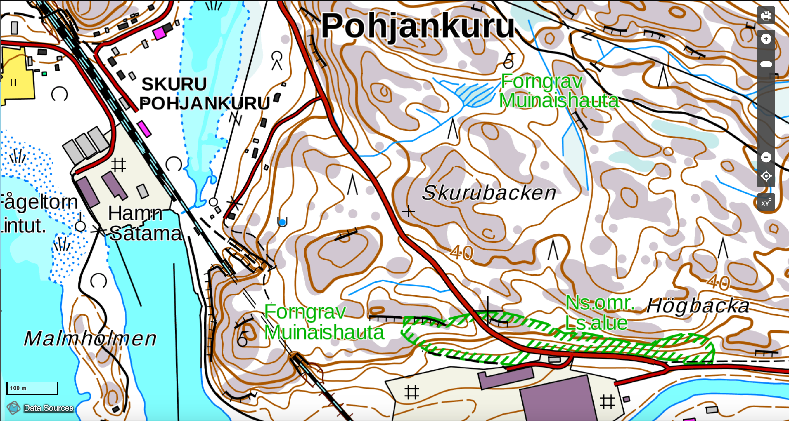
Two other mound sites I had not yet visited in the immediate environs of Pohja are located on Skurubacken (Swedish for Pohjankuru Hill, “Pohjankuru” being Finnish for Bottom Gorge—see map below), not to be confused with Skuruberget (Gorge Mountain). Skurubacken is located southeast of the village of Pohja and due south of Skuruberget. The gorge or kuru/skuru that finds its way into these place names divides the two hills from each other and was carved out by two rivers—the Fiskars River from the northwest and, to the south, the Svartån River from Bilnäs and Karjaa to the east. I am not yet sure what created the gorge (making way for Highway 111, otherwise known as Åbovägen in Swedish and Turuntie [the Turku Road] in Finnish) that separates Skuruberget from Skurubacken.

Science & Geomantic Intuition: Using Official Maps and Psychic Visions
At the time I first visited these sites on 19 November 2019, I was dependent on the maps from the National Land Survey of Finland, which I refer to in earlier posts. But a day or two later I discovered a better iteration of that map that provides links and detailed information about each of the ancient sites listed. That more detailed map site is from Museovirasto, the Finnish Heritage Agency. This mapsite opened up my comprehension of the local geomantic landscape dramatically, giving me already-agreed upon names for the sites I had already discovered as well as a much-enlarged scope of field of sites I had not yet identified.
As I mentioned briefly above, in the months leading up to our move back to Finland at the end of May 2019, I had been receiving intuitional information regarding the energetic geomantic spirit-scape of the Tammisaari-Pohja-Fiskars region. This is, for me, the primary source of authority in my understanding of the energetic nature of the area. I could already see the general configuration of these ancient sacred locations even while I was physically located in the United States. And once we moved to Fiskars in August of 2019, these intuitional arrays grew much clearer. My discovery just a few weeks ago (after first visiting Skurubacken) of the Museovirasto maps provided me with the scientifically-accepted understanding of these sites. For the moment (within this blogpost) I am now referring to the official names of these sites as provided by Museovirasto. This will help others to locate the sites that are officially recognized by these official archaeological agencies.
Here is a close-up of the Museovirasto map showing the two recognized sites on Skurubacken:

The first site I visited on 19 November is seen at the top of the map, marked by the red circle identified as Skurubacken (just above the green words reading Forngrav/Muinaishauta). The second site is located towards the bottom left beside the other red circle marker indicating the sitename of Tunnelberget (beside the other green “Forngrav/Muinaishauda” location).
A Tale of Two Mounds
Skurubacken covers a large area characterized by endless rolls of cliffs and trenches. The boulders tend to be covered with the regionally-typical greenish-white lichen called jäkälä, as seen in the photo below:

Like most of the environs of this part of Raasepori, the spongy green areas between the boulders are wet and marshy:

Cairn 1: Skurubacken North
Before discovering the Museovirasto mapsite, I was referring to the northernmost site here as Skurubacken North. I later learned that the official designation is simply “Skurubacken.” My experience here on 9 November was initially confusing because I had been expecting another clifftop cairn overlooking the bay, just as I had found on the other berget clifftops. But this stone site, which I could identify both because of GPS and my geomantic intuition, was simply a tumble of moss-covered stones that clearly had not been excavated yet by archaeological teams. On a logical level, I was wondering if the GPS marker system on my Natural Land Survey iPhone app was inaccurate, but my intuition told me that this was indeed the spot referred to on the map. The following photographs give a general sense of what I found there:

Below you can see how the Skurubacken site appears to be an unexcavated stone site, with moss growing on top of the stones and wild brambles on the ground:


In my initial notes after my first visit here I wrote the following description of my experience:
One mysterious element of the northern Skurubacken site is the fact that it does not currently face Pohja Bay. As we have seen, each of the other sites I have visited so far involve a dramatic view of the bay from the high cliffs above Pohjankuru and the village of Pohja. But this site, even were it to conform in appearance to the others and take the shape of a massive exposed rock pile, is located below the horizon-level cliffs surrounding it. Even if we imagine the time when the sea waters climbed much higher up the hills than they do today, the surrounding cliffs would still block the view of the bay from this location (assuming it is, in fact, located on the spot indicated by the map).
This suggests either that this site served a different function in terms of horizonal perspective and the energetic complex resulting from such a phenomenoligcal positioning of the celebrants at the site OR that the actual site lies elsewhere on the cliff top (which would mean that the map marking is inaccurate, which so far has not been the case). [I later found that the mapo markings were indeed accurate.] If so, we would (and still might) find the cairn up on the bayside cliffs, such as the spot pictured below [end of initial notes]:

While I later found that the maps and GPS coordinates for the Skuruberget site were accurate and that they did not refer to some mystery site on the cliffs overlooking the sea, I will say here that such does not preclude the possibility that the sea-facing cliffs on Skuruberget were actually ceremonially recognized by various ancient peoples of the region. This is what my geomantic intuition tells me—I feel that energetic radiance in the cliffs of the immediate area.
Cairn 2: Skuruberget South Site—Tunnelberget
After accepting that this first site of the day did not conform to my previous expectations, I returned to my car and drove to an accessible spot for access to the second site listed, which I initially called Skuruberget South but later discovered is actually referred to as Tunnelberget, named after the still-used train tunnel that was dug beneath the clifftop cairn site. Tunnelberget is situated beside the bay, with the shipyard to the northeast of the tunnel and the bay opening out to the southwest down towards Tammisaari.


Leave a Reply